


Canada Fact Cards
Digital Download
Enjoy instant access to your Montessori printables. This is a digital product - no physical items will be shipped.
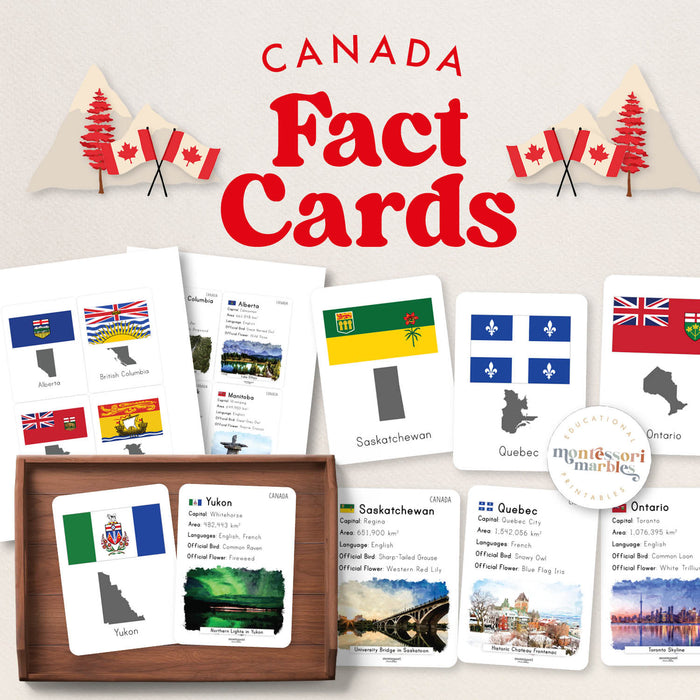
Teach your elementary student Canadian geography with these comprehensive province and territory fact cards. Each card includes the flag, map, capital, population, official bird and flower, plus places of interest for all 10 provinces and 3 territories for ages 6 to 10.
📦 What's Included
- 14 fact cards: One for each province and territory
- Double-sided format: Front shows flag and map, back includes detailed facts
- 8 pages total: Complete Canadian geography reference
- Card size 3 in. x 4 in.: Easy to handle and store
- Comprehensive information: Province name, capital, population, languages, official bird, official flower, place of interest with watercolor illustration
💡 Learning Benefits
- Canadian geography learning all provinces and territories
- Cultural knowledge understanding regional symbols and languages
- Research skills using cards as reference material
- Reading practice processing factual information
- Memory development visual and textual learning combined
🎯 How to Use
- Introduce one province or territory per week for deep study
- Use during Canada Day unit or year-round geography lessons
- Practice matching flags to province names
- Create research projects using card information as starting point
- Quiz students on capitals, official symbols, or populations
- Perfect for homeschool Canadian geography curriculum
🍁 Facts Included Per Card
- Province or territory flag
- Province or territory map
- Province or territory name
- Capital city
- Population
- Languages spoken
- Official bird
- Official flower
- Watercolor illustration of place of interest
🗺️ Teaching Tip from a Montessori Guide
Fact cards work best when paired with hands-on exploration. After introducing a province using the card, children can locate it on a physical map of Canada, research additional facts online, or create their own mini-reports. The double-sided format allows for self-checking during independent study. Consider creating a "Province of the Week" rotation where children become experts on one region at a time, then teach their findings to family members using the cards as visual aids.
🔗 Pair This With
- Canada Cutting Strips – Fine motor practice with Canadian theme
- Canada Pattern Matching – Visual skills with Canadian symbols
- Fact Cards Collection – More geography reference materials
