


Continental Fact Cards Bundle
Digital Download
Enjoy instant access to your Montessori printables. This is a digital product - no physical items will be shipped.
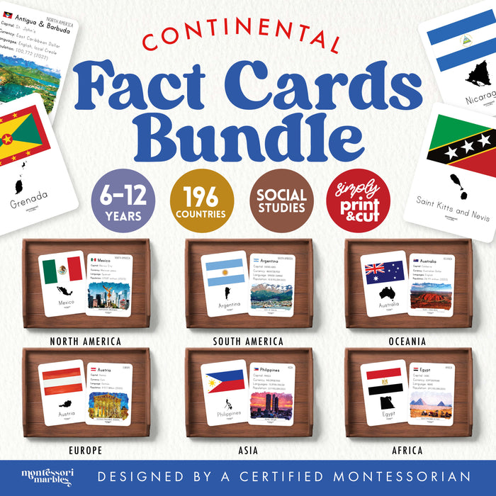
Transform your elementary geography curriculum with this complete Continental Fact Cards Bundle covering all 196 countries across six continents. Every country card features flag, map, capital, currency, language, population, and a watercolor landmark illustration in this comprehensive world geography resource for ages 8 to 12.
📦 Complete World Geography Collection
- 196 double-sided country cards: Every recognized nation on Earth
- Six continent sets included: Asia, Africa, Europe, North America, South America, Oceania
- Card size: 3 inches by 4 inches, perfect for elementary hands
- Front side: Country name, flag, detailed country map outline
- Back side: Capital city, official currency, primary language, population, watercolor landmark painting
- Print ready: Organized by continent for easy classroom management
💡 Why Montessori Elementary Classrooms Need This
Saves 40+ Hours of Prep Time: No more searching for accurate country facts, designing layouts, or finding appropriate images. Every card is research-ready and beautifully designed for immediate use.
Supports Independent Research: Children conducting continent studies can pull cards for countries they're researching without waiting for teacher assistance. Facts are accurate, age-appropriate, and comprehensive enough for elementary reports.
Enables Differentiated Learning: Younger elementary students use cards for simple fact gathering. Older students compare currencies, analyze population distributions, or study linguistic patterns across regions.
Completes Your Geography Shelf: These cards work alongside map puzzles, globes, and continent boxes as the factual reference children need when Montessori cultural materials spark curiosity about specific countries.
Unlimited Printing Rights: One purchase equips your entire classroom forever. Print multiple sets for small group work, send copies home with students, or replace worn cards without repurchasing.
🎯 How Elementary Teachers Use These Cards
- Continent study stations where children research assigned countries
- Independent reference tool during geography work periods
- Small group activities comparing countries within regions
- Supplement to map puzzle extensions and globe work
- Research starter for country report assignments
- Cultural studies exploration connecting countries to students' heritage
- Geography games matching capitals, currencies, or landmarks
🌍 What Makes This Bundle Essential
Every Country Matters: Commercial geography sets often include only 30 to 50 major countries. This bundle includes all 196 nations, respecting that children's families and interests span the entire globe.
Accurate, Current Information: Facts reflect current geopolitical reality. No outdated currencies or incorrect capitals that confuse elementary learners.
Beautiful, Educational Art: Watercolor landmarks introduce children to iconic sites like Machu Picchu, Taj Mahal, Eiffel Tower, and Great Wall while maintaining educational focus on factual information.
Montessori-Aligned Design: Clean layouts, readable fonts, accurate maps, and organized by continent matching how Montessori geography curriculum progresses from whole to parts.
📚 Bundle Breakdown by Continent
- Asia: 48 countries from Afghanistan to Yemen
- Africa: 54 countries across the continent
- Europe: 44 countries including smallest nations
- North America: 23 countries including Caribbean nations
- South America: 12 countries from Colombia to Chile
- Oceania: 14 island nations and territories
💰 Investment That Pays Off
Compare the alternatives: Individual continent card sets typically cost $5.95 to $7.95 each. Buying all six separately would cost $48.70. This bundle saves you $20.75 while giving you the complete world geography reference your classroom needs.
Cost per classroom use: At $27.95 for 196 cards with unlimited printing, you're paying $0.14 per country for a resource children will use throughout elementary years. Print two complete sets for $0.07 per country per set.
Replaces expensive materials: One bundle eliminates need for multiple geography reference books, printed atlases, or expensive country fact posters while providing more comprehensive information.
🎓 Teaching Tip from a Montessori Guide
Introduce these cards after children have worked extensively with continent map puzzles and globes. When a child shows interest in a specific country on the puzzle, hand them that country's fact card. This progression from concrete sensorial exploration to abstract factual research mirrors Montessori's from-concrete-to-abstract principle perfectly.
📊 Bundle Specifications
- Age range: 8 to 12 years old (Lower and Upper Elementary)
- Total cards: 196 double-sided country cards
- Card size: 3 inches by 4 inches
- Continents covered: Asia, Africa, Europe, North America, South America, Oceania
- Format: Printable PDF (print unlimited copies)
- Recommended materials: Cardstock paper, laminator for durability
🔗 Build Complete Geography Curriculum
- Seven Continents Flash Cards - Start with continent introduction
- Seven Continents Nomenclature Cards
- World Marketplaces Photo Binder
