


Oceania Fact Cards
Digital Download
Enjoy instant access to your Montessori printables. This is a digital product - no physical items will be shipped.
Explore the diverse nations of Oceania with this printable PDF fact card collection for ages 7 to 12. Students discover 14 countries spanning Australia, New Zealand, and Pacific island nations through double-sided cards featuring flags, maps, essential country facts, and watercolor illustrations of significant landmarks, designed to support independent research and continent studies with comprehensive geographic and cultural information.
📦 What's Included
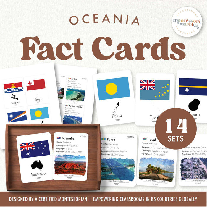
- 14 Double-Sided Country Cards: Each card measures 3.5" x 5" with information on both sides
- Front of Card: Country name, national flag, and country map showing location and shape
- Back of Card: Country name, essential facts (capital city, currency, official language, population), and watercolor painting of famous landmark or landscape
- 8 Total Pages (print double-sided for complete cards)
- Countries Included: Australia, New Zealand, Papua New Guinea, Fiji, Kiribati, Tuvalu, Palau, Marshall Islands, Solomon Islands, Tonga, Nauru, Vanuatu, Micronesia, Samoa
💡 Learning Benefits
- Build geographic knowledge of Oceania's nations, including often-overlooked Pacific island countries
- Develop research skills by consulting cards for specific country information during projects and reports
- Practice cultural awareness through exposure to diverse Pacific nations beyond Australia and New Zealand
- Connect flags, maps, and landmarks to create mental associations that strengthen memory
- Support Montessori cosmic education studies exploring human diversity and global citizenship
🎯 How to Use
- Place on the geography shelf as reference materials students consult during continent studies
- Use alongside Oceania puzzle maps to connect country names with physical locations
- Encourage students to research one country at a time, creating their own follow-up reports or projects
- Display cards during geography lessons introducing Oceania's unique island nations and cultures
- Pair with world map activities to help students locate these Pacific nations in the vast ocean
🌏 Why These Countries Matter
Oceania includes some of the world's smallest and most geographically isolated nations, making them easy to overlook in geography studies. This collection ensures students learn about Nauru, Tuvalu, Palau, and other Pacific island nations alongside larger countries like Australia and New Zealand. The watercolor artwork captures the stunning natural beauty of Pacific landscapes, coral atolls, and cultural landmarks that make this region unique.
🔗 Complete Your Continent Studies
- Australia & Oceania Collection for more Pacific region activities
- Geography Collection for world studies and continent materials
- Fact Cards Collection for other continent and topic fact cards
